
How Do I Get to the Top of Diyaluma Falls?
Diyaluma Falls is admired from the road by plenty of travelers. But the top, where the natural pools sit, isn’t reached that easily. A hike is involved, and there are two different routes used to get there. This guide walks through Diyaluma Falls’ location, both routes to the top, and everything needed to make the climb safely.
Where Is Diyaluma Falls Located?
Diyaluma Falls is located along the Colombo–Badulla highway, in Sri Lanka’s Badulla District. It sits roughly 30 kilometers south of Ella and about 6 kilometers from the small town of Koslanda. The falls drop 220 meters in a single plunge, making this the second-tallest waterfall in the country.
Depending on which route is used, Diyaluma is reached in about an hour by tuk-tuk from Ella, or roughly an hour along winding roads from Haputale. Because of its location right along a major road, the base of the falls is seen without much effort. The top, however, is a separate destination entirely, reached only after one of the two routes below is completed.
Two Routes to the Top of Diyaluma Falls
Two main routes are used to reach the upper pools and the top of the falls: the Koslanda–Poonagala Route, a more established path reached by road through Koslanda and Poonagala, and a second, rougher back-road route, reached via a turn-off found directly along the way from Ella. Neither route requires a guide, though guides are available on both.
Both are detailed below, from the drive in to the hike itself.
Route 1: The Koslanda–Poonagala Route
This route is reached by road rather than a direct trailhead turn-off, and it’s generally considered the more established of the two ways up.
Getting there. The route starts by reaching Koslanda town first. From there, a turn is taken onto the Bandarawela–Koslanda–Poonagala road. This road is followed until Lower Poonagala is reached, and from there, the route continues to the Makaltheniya junction in Lower Poonagala. This junction leads directly to the Upper Diyaluma Trek start point, where the hike itself begins.
Follow the attached route map for the exact turns along this road. Google Map
The hike down. From the trek start point, the path heads downhill through long, dry grass and takes around 30 minutes. The path is uneven in places and overgrown in others, so proper shoes are worth wearing rather than sandals—light scratches on exposed legs are a common complaint otherwise. Plenty of water is worth carrying too, since the heat and humidity along this stretch can be intense.

Reaching the upper falls. The sound of rushing water is usually heard before the falls themselves come into view. Before long, a viewpoint over the upper falls appears, and the path begins to descend more sharply toward the lower section.

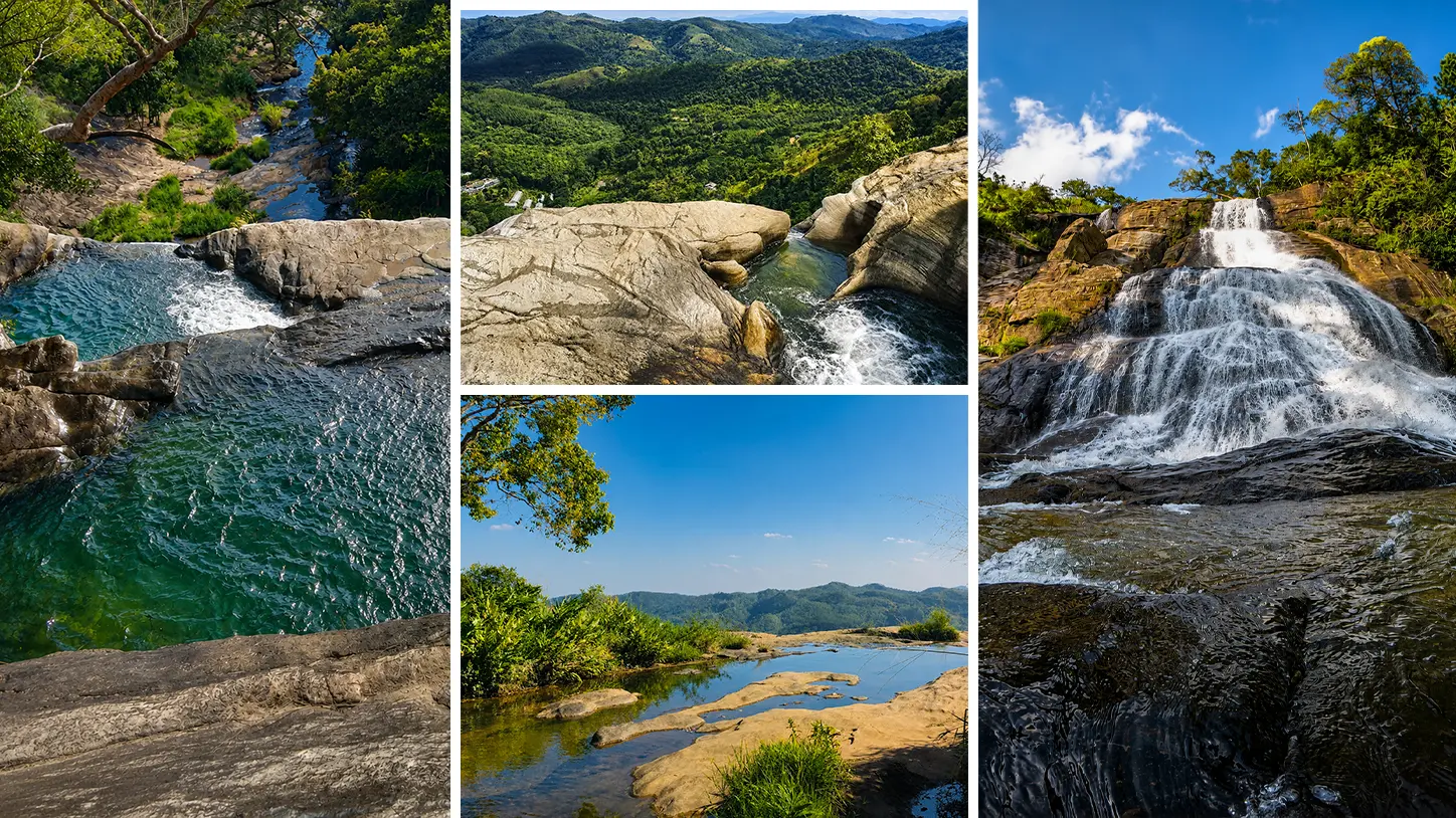
Continuing to the pools and lower falls. With time to spare, a path to the right leads up toward the top of Diyaluma Falls, where more manageable natural swimming pools are found. From there, the same pathway continues down toward the lower falls — the final stretch of Sri Lanka’s second-tallest waterfall, with its full 220-meter drop to the valley floor below. The path isn’t signposted on this route, but it’s easy to follow and appears to be well maintained throughout.

Route 2: The Back-Road Route (via Ella)
This route starts from a turn-off found directly along the main road from Ella, and it’s used by travelers who’d rather access the falls without going through Koslanda or Poonagala at all.
Take this turn. If arriving from Ella, a track is spotted about five minutes before the lower falls lookout is reached. A right turn is made up of this track.

Expect a rough road. Concrete lasts for a minute or so before turning to broken rubble. This stretch is considered one of the worst roads a tuk-tuk is likely to be driven along—regular cars can’t manage it at all, and even a motorbike ride here isn’t especially comfortable.
Reach the cluster of buildings. After roughly 10–15 bone-shattering minutes, a small group of buildings is reached.

Find the dirt track by the white building. A track is found on the left side of the road, just past a white building. It’s followed as it crosses two small streams and curves right toward a small group of houses.

Go left before the orange house. The track continues between the buildings—just past the orange house and before a blue one—leading down toward another stream. This stretch can feel a little unusual, since it passes what feels like private garden space, though locals along the way have generally been welcoming, with smiles and waves rather than any concern.
Follow the path to the top of the ridge. A steady, uphill climb begins here, passing a green house and a blue house, then turning down a narrow alley just before another orange house. The path is now almost entirely uphill and rocky and can be slippery—best avoided if it’s recently rained. After about 15 minutes, a flatter section is reached, and the path curves left toward the top.

Start the loop. Once the ridge is reached, the path continues straight ahead. As the edge gets closer, the sound of water becomes noticeable. A choice is made here—right toward the smaller infinity pools or left toward the very top of the falls. Going right first is generally recommended, since the steeper sections are climbed upward in this direction rather than walked down, which tends to be more slippery.

The upper pools are found close to a distinctive black rock formation—one pool to the right, three more to the left. The pool on the right is considered completely safe and a good option if recent rain has increased the flow elsewhere. The first pool to the left is usable too, depending on conditions, and generally fine during the dry season. The remaining two pools require sliding down a section of cliff face with significant drops on either side and are best left to more experienced or risk-tolerant hikers.

Take the path down. Returning the same way isn’t required to continue the loop. A smaller trail leads instead toward the very edge of the falls—extra care is needed here, since the rock is slippery.
The top of Diyaluma Falls is the part most people come for. Views stretch for miles in every direction, with a sheer, dramatic drop below that makes it feel like standing on top of the world. Timing the arrival matters—visiting early in the day is recommended, or visiting at midday and allowing time to wait for other visitors to move on is also an option. Late afternoon visits come with an added caution, since wild elephants are known to roam the Diyaluma area at this time.
What to Bring, Whichever Route Is Chosen
- Sturdy, closed-toe shoes—both routes include uneven, sometimes overgrown or rocky ground
- Swimwear, worn underneath hiking clothes, for the pools at the top
- Plenty of water—no shops are found on either route once the trek begins
- Sun protection, since both routes offer little shade
- Cash, for tuk-tuk fares and any entrance arrangements along the way
- An offline map saved in advance, particularly useful given limited mobile service in the area
Best Time to Attempt Either Route
Mornings are recommended for both routes. Cooler temperatures, softer light, and quieter trails are all found earlier in the day. The dry season is preferred overall, since firmer footing and calmer pool conditions are more likely. Late afternoon hikes are best avoided, partly due to fading light and partly due to increased wildlife activity reported in the area at that time.
A Quick Safety Note
Both routes involve real cliffs, slippery rock, and pools without barriers, so ordinary caution matters throughout—stay back from edges, avoid wet rocks, and check swimming conditions locally before getting in. A full breakdown of safety considerations for the hike is covered in our dedicated safety guide, worth reading before setting out.
Final Thoughts
Reaching the top of Diyaluma Falls takes a bit more effort than viewing it from the road, but most travelers say it’s worth every step. Whether the Koslanda–Poonagala Route or the back-road route via Ella is chosen, the payoff at the top — natural infinity pools and sweeping valley views — is rarely matched elsewhere in Sri Lanka’s hill country.


